Useful information about the taxon (species, subspecies, variety...)
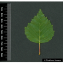
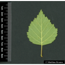
Betula obscura Kotula
Betulaceae
(APG IV)dark birch
Akzessionnummer: LG-V-005-15350
Pflanzjahr: 1998
Patenschaftstext: Fam. Prof. Dr. Ing. Dr. h.c. H. D. Kutzbach
Taxon concept: The Plant List (2014), version 1.1
Distribution: Silesia, Slovakia
Betula obscura Kotula - Accepted: Betula obscura Kotula bei The Plant List (2010); Familie: Betulaceae (APG III)Betula obscura Kotula - Accepted: Betula obscura Kotula bei The Plant List (2014), version 1.1; Familie: Betulaceae (APG III)Betula obscura Kotula - Accepted: Betula obscura Kotula bei The Plant List (2010); Familie: Betulaceae (APG IV)
- Difference to related species
- nuts sizes are smaller than those of common birch (Betula pendula)
- Flowers
- monoecious flowers
- Flower ecology
- wind-pollinated (anemophilous)
- Life form
- tree
- Foliage persistence
- deciduous
- Fruits
- winged nut fruit (samara)
- Fruit ecology
- wind-dispersed (anemochorous)
- Soil conditions
- preferentially on fresh, nutrient-poor soils in submontane areas
- Natural occurrence (habitat)
- scrub and pioneer woodland of forests clearings, acidophilous oak forests, oak-hornbeam forests, alluvial forests, alder carrs, willow carrs, birch woodlands, Cirsium meadows
- Vegetation typ and synecology (plant community)
- temperate, mixed broad-leaved deciduous forests
- Constraints according soil conditions
- not salt tolerant
Erhardt, W., Götz, E., Bödeker, N. & Seybold, S. (2008): Der große Zander. Enzyklopädie der Pflanzennamen. Band 2. Arten und Sorten. Eugen Ulmer KG, Stuttgart (Hohenheim), 18. Aufl., 2103 S.; Global Biodiversity Information Facilty (GBIF). Online Publication: www.gbif.org; Oaks of the World (Accessed: 2018): Quercus dentata. See: http://oaks.of.the.world.free.fr/quercus_dentata.htm; Plants for a Future (1996-2012): PFAF. See: https://pfaf.org/; The IUCN Red List of Threatened Species. www.iucnredlist.org;
Diese Webseite verwendet Google Maps, um Karten und Standorte von Pflanzen in den Hohenheimer Gärten anzuzeigen. Dadurch werden unter Umständen Daten an Google weitergeleitet, was mit einer Verarbeitung Ihrer personenbezogenen Daten verbunden sein kann. Die Datenschutzerklärung von Google finden Sie hier: Datenschutzerklärung von Google


